
Gordon Chaffin: DC should buy an auto repair store — and other ideas for enhancing safety along Florida Avenue NE
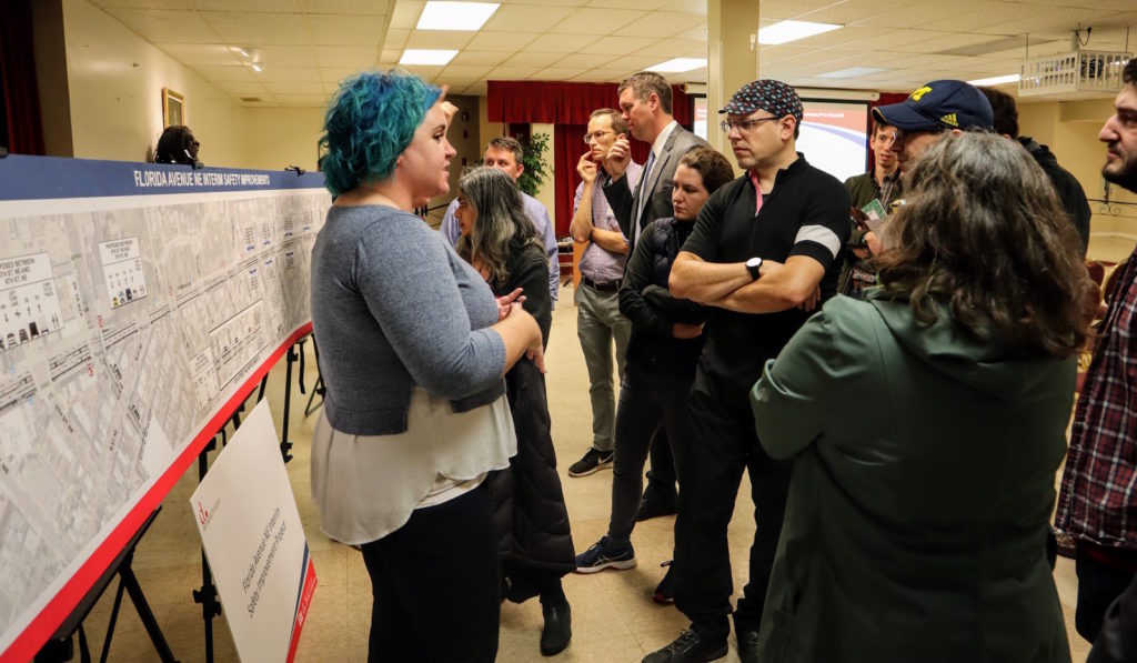
Earlier this month, the District Department of Transportation (DDOT) presented designs for safety enhancements and road reconstruction for critical areas of Near Northeast DC in NoMa and Union Market, extending eastward through Trinidad to Kingman Park. However, there remain serious faults and omissions with the agency’s plans. In order to prepare those neighborhoods for safety amid fast-growing residential and commercial activity, DC must beef up these plans with less emphasis on accommodating fast car travel.
Prioritize safety on Florida Avenue NE from 2nd to 14th streets NE
To protect pedestrians and cyclists, DDOT must substantially change its latest design for reconstruction of Florida Avenue NE. The large capital project slated for 2021-22 construction will widen sidewalks and make permanent most of the interim changes installed in summer 2019. However, the partial design for permanently reconfiguring for the corridor does little to improve the conflict points observed by frequent users at intersections and the hazards posed by frequent misuse of road space by motorists.
Still unaddressed, the following design flaws have presented regular hassle and harm to frequent users of the corridor — myself included. I ride on this corridor five to six times per week to and from a recurring appointment. These are issues highlighted by my reporting and personal experience.
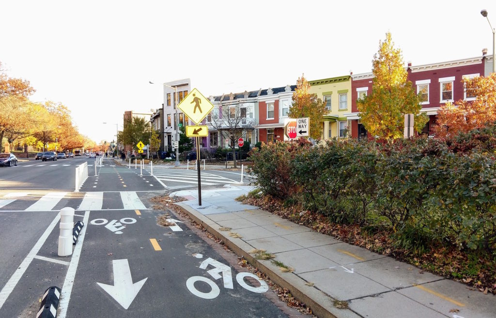
DDOT’s updated Florida Avenue NE design does not change the daily, hourly blocking of the street’s sidewalk and cycle track by motorists waiting in line to enter Mac’s Tire Service at 423-425 Florida Avenue NE. The business is a one-way drive-through, and queued motorists blocked the sidewalk and the far-right travel lane before the cycle track was installed. Now, waiting drivers block the sidewalk, cycle track and far-right travel lane. This is both unsafe and illegal.
Neither DDOT nor DC’s Department of Public Works (DPW) has systematically intervened to stop this daily misuse of public space. Over the past few months, passersby have occasionally reported violations by calling 311 — the District’s citywide call center. Enforcement officers have arrived on scene anywhere from 30 minutes to a few hours later; they’ve even ticketed, but soon after they’ve left, different cars are in the same spot, idling in the sidewalk and bike lane. I have occasionally asked Mac’s staff to move the car line back into the travel lane and done a lap around the block. When I’ve returned, the same motorists have been blocking the sidewalk and bike lane.
At DDOT’s open house this month, neither director Jeff Marootian nor project staff proposed any kind of systemic, weightier intervention to solve this problem. When I suggested legal action to seek a memorandum of understanding with Mac’s management, Marootian told me “that’s an interesting idea.” I believe the ultimate solution to this repeat-offending safety hazard is for DDOT to use eminent domain to purchase the three Mac’s parcels on Florida Avenue.
The District is pursuing use of eminent domain to buy a Wendy’s for $6 million to make Dave Thomas Circle, also on Florida Avenue NE, safer. Why not buy an auto repair store for less than half as much? Why is this less important when children walk by this spot every day from the charter school right next door? In regard to actually fixing this problem in a permanent way, DDOT’s answer was, “We’ll look into it.”
Extend cycle track westward under railroad bridge
Right now, westbound cyclists encounter an abrupt end to the cycle track at 3rd Street and Florida Avenue NE. To progress underneath the railroad bridge, bikers either have to ride on the very narrow south sidewalk under the bridge or use the crosswalk to go north and enter the westbound car travel lane or traverse the also very narrow north sidewalk. The north sidewalk is in particularly poor condition thanks to apartment construction just to the west of the tunnel.
In order to connect the Florida Avenue NE cycle track and pedestrian enhancements to Dave Thomas Circle and NoMa, DDOT must extend the cycle track from 2nd Street NE westward to 1st Street NW. Agency staff told me this was their intention, but the designs presented did not reflect that needed improvement. It’s important to act now to maximize pedestrian safety and access in the streetscape at 3rd Street, N Street and Florida Avenue NE because a new entrance to the NoMa-Gallaudet U Metro station will be built at this intersection in the coming decade. With lots of pedestrian and bike traffic heading to new-growth areas to the north and east, DDOT can’t skimp on safety and capacity.
Fix poor visibility at non-90-degree intersections
While DDOT’s partial design for Florida Avenue NE’s permanent reconstruction creates concrete curb extensions at intersections, the updated plan does not improve problems evident from the road’s interim improvement. Visibility of pedestrians and cyclists on the southside cycle track and sidewalk is poor as motorists enter or exit the non-90-degree intersections of Florida Avenue with M Street, L Street, Montello Avenue and I Street NE.
Sightlines could be improved by repositioning the crosswalks so motorists don’t have to creep into them before getting a clear view of oncoming pedestrian/bike traffic and vehicle traffic in both directions.
Stop motorists from performing curbside pickup/drop-off unsafely
Six months after the installation of Florida Avenue NE’s interim safety improvements, it has become clear to me and other road users I’ve talked to that any exposed curbside space will be used as pickup/drop-off zones. Motorists routinely block the road’s curbside lane, where bike lane protection breaks off to give vehicles a right turn lane and to provide curbside space for bus stops. This occurs despite concrete bus pads, paint indications of a bike lane and turn-only lane, and signs banning motorists from parking or standing.
Nonetheless, DDOT’s updated Florida Avenue design for the permanent road improvement leaves these curbside zones unchanged. That would enshrine an unsafe, illegal use of the road and require the most vulnerable road users to pester motorists “just stopping for a minute” when even a second of unsafe road use can mean tragedy. The agency doesn’t want to install bike lane protection and floating bus stops in these spots because stopping buses would block the car travel lane. However, the current arrangement is more dangerous than that inconvenience.
Add the missing bike lanes on West Virginia Avenue NE above Florida
While DDOT’s updated Florida Avenue NE plan includes new protected bike lanes on West Virginia Avenue, those facilities would extend only south of Florida Avenue to H Street NE. This leaves West Virginia — an unsafe, high-traffic road — unchanged where it cuts through high-growth Trinidad and Ivy City communities. Pedestrians and cyclists can’t make it safely to the new Ivy City Target without safer designs on West Virginia Avenue NE, New York Avenue NE, Brentwood Parkway NE, Mount Olivet Road NE and Bladensburg Road NE.
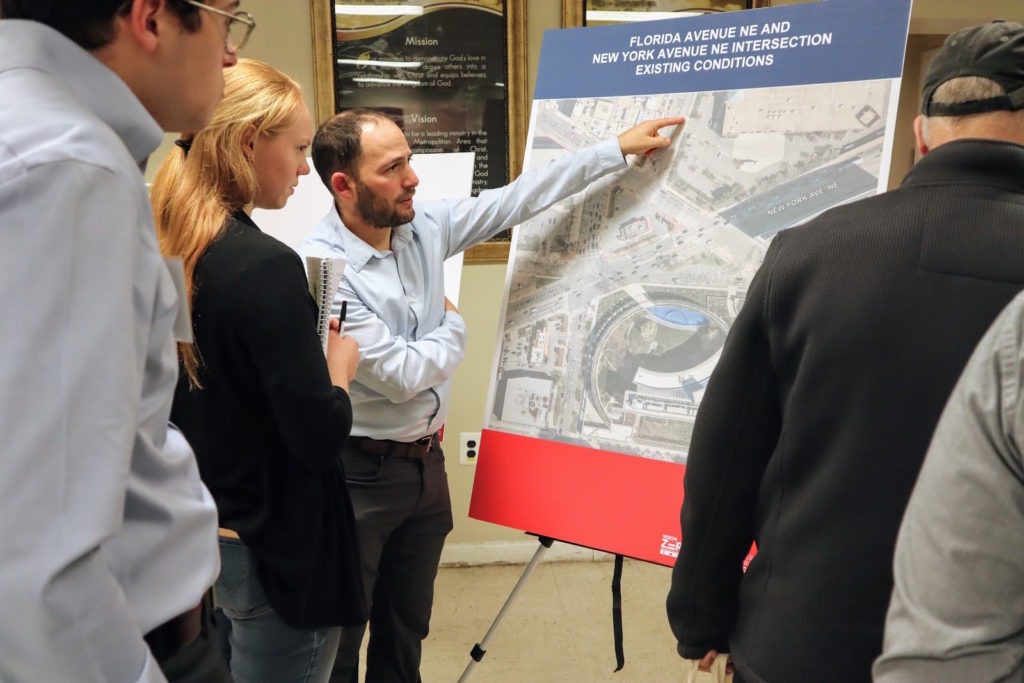
For Dave Thomas Circle, implement a road diet and create direct connections
During its December open house, DDOT showed an early version of detailed designs for the reconfiguration of Dave Thomas Circle, a capital project intended to rectify one of the District’s most confusing, dangerous crossings. If the current proposal becomes final, the Wendy’s location that gives the intersection its nickname will be demolished. Where the restaurant sits now, DDOT would create a new island park with a shape better suited to the crossing traffic lanes. The changes would get rid of the dangerous slip lane near the U.S. Bureau of Alcohol, Tobacco, Firearms and Explosives headquarters that carries eastbound traffic from New York Avenue to Florida Avenue.
Despite the improved sidewalk and bike lane facilities it would provide, the design fails by not rethinking the intersection’s core function: It preserves the width and number of lanes on Florida and New York avenues so they can continue accommodating higher-speed vehicle traffic. The agency’s plan forces bike traffic on these two thoroughfares to zigzag north/south on 1st Street NW or Eckington Place NE. That requires navigating sidewalks with high-pedestrian volume and adds three to five minutes to a trip through the intersection. Forcing so many turns also inhibits the increasingly common use of large cargo bikes by families getting to and from school or recreation. DDOT should instead build protected bike lanes through the intersection on Florida Avenue, as recommended in a recent study of the area by the Urban Land Institute (see page 25).
One could say it’s too dangerous to ride a bike or even walk alongside New York and Florida avenues — but changing that is precisely the point of this long-delayed project. DDOT should be making these roads safe and inviting for all users, all ages, all abilities. To achieve that goal, DDOT must reduce the number of vehicle travel lanes through Dave Thomas Circle. Providing protected bike lanes and widened sidewalks improves safety for everyone, in part by lowering motor vehicle speeds. In contrast, maintaining the circle’s wide roadways perpetuates a fundamentally unsafe design imperiling the safety of future generations of residents and visitors in one of DC’s fastest-growing corridors.
The communities connected by Florida Avenue NE and those around Dave Thomas Circle are growing fast with more residents, housing units, retail and recreational establishments. More people are walking, biking, riding scooters and boarding buses in this area than ever before.
Commuters may drive along these corridors, but that does not mean these areas are primarily commuter corridors. Florida Avenue isn’t just a direct way to get to the Benning Road/I-295 interchange. In order for these communities to have the transportation options they deserve, DDOT needs to push safety even further to the forefront. There will need to be trade-offs, like slowing car traffic down, and that should be intentional. It’s safer for everyone that way.
Gordon Chaffin is a reporter for Street Justice, a daily email newsletter covering transportation and infrastructure throughout the Washington region, especially in less privileged, rapidly changing neighborhoods. Street Justice produces a free, weekly digest on Sundays and publishes daily reports for subscribers that include a story, a calendar of local public meetings and a list of projects open for public comment. To submit a pledge for a subscription, click here.
I wonder if it would be possible to have cars go through Mac’s in the opposite direction? It looks like there is enough space behind the building for at least a couple to queue up without blocking the alley. There would still be a conflict with the bike lane and sidewalk but not a standing line of cars.